
Abstract
The aim of this paper is to design optimization of crisis management in the municipality. It is, therefore, necessary to create a system that increases efficiency in addressing crisis situations. The system is composed of three basic parts. The first part defines the procedure for qualified assessment of current security situation in selected municipality. The second part is focused on the specification of selected groups of objects. The last part of the article is focused on integration of acquired data into a geodatabase to streamline extraordinary event or a crisis situation in the municipality.
1 IntroductionCrisis management is focused on preparing and managing emergencies or crisis situations. The essence of crisis management is to defense affected system by an emergency or a crisis situation before irreversible degradation. It is, therefore, to stop the degradation in stabilized level with necessary number of essential system functions.
Crisis managers are under great pressure stemming from several sources, such as: lack of time for decision-making, lack of information, claims for mental endurance and experience of individuals [3].
On the basis of the priorities highlighted above, it is necessary and desirable to improve efficiency of crisis management and planning. Especially, when we talking about the issue of handling and sharing information related to critical issues, because the information itself is the most important element in the solution of the crisis situation. Therefore, it is appropriate to implement information technology in the whole structure of crisis management and planning to accelerate information management, decision-making and cognitive processes
This article is focused on the optimization of crisis management in the municipality. This is achieved by connecting relevant information, which are needed to solve an emergency or crisis situation. Geographic information system was chosen as integrating element of the system.
2 Specifications of the municipalityIn the interest of evaluation of possible threats, it is necessary to analyze the current state of the security situation in the municipality. This requires quantitative and qualitative methods to perform safety analysis. Qualified analysis is the first step to creating effective countermeasures and effective solution to the crisis. This practice is applied in each group, as shown in Fig. 1. Synergies between obtained data allow to achieve information on a qualitatively higher level, which can be used in the context of other analytical activities.
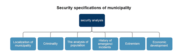
Figure 1 – The fields of security analysis [source: Author]
3 Analysis of selected objectsThis chapter is focused on objects within the municipality, which can be defined as crowded places or as a source of potential danger to the population. The objects are subject to safety analysis. Important data are digitized and ready for further processing in the context of geodatabase.
3.1 Crowded placesCrowded places are places or objects where is a significant concentration of population. Such objectives are very susceptible to critical events that would cause a great loss of human lives. Nowadays, the crowded places are mostly associated with terrorism. However, it is necessary to analyze crowded places in relation to other threats.
Crowded places are topics that can be divided into two groups. The first group contains objects which are constantly used by the population (eg. metro, stadiums, schools, shopping centers). The second group contains objects and locations that are used temporarily (eg. festivals, road races). Many of these objects may be utilized for solving emergency situations as a destination area for evacuation [1].
Crowded places such as schools can be integrated into geodatabase. To optimize planning and crisis management there can be used digitizing floor plan drawings as you can see at Fig. 2. These data are integrated into the geodatabase.
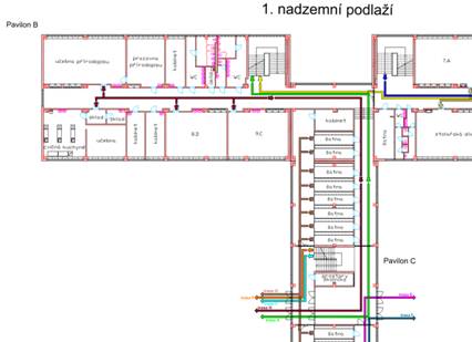
Figure 2 – Digitization of the ground plan drawings [source: Author]
3.2 Objects representing a potential risk for the populationIn this particular case, the objects contain a lot of hazardous substances. Every emergency situation could lead to release of hazardous substances, which would affect a large amount of the population. In this article, we distinguish between group of pumping stations and a group of industrial buildings. We can use modeling software TerEx to optimize crisis management within the described objects for simulation of leak harmful substances (Fig. 3). The program deals with the impact of hazardous chemicals, toxic substances or explosive devices. This is a modeling system that displays its results on maps [2].
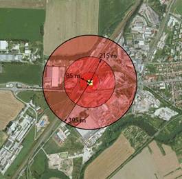
Figure 3 - Area affected by the explosion [source: Author]
4 Optimization of crisis Management in Municipality via GISThe aim of this chapter is to establish a general geodatabase. It is a prime example of how to optimize crisis management and planning within any municipality in the Czech Republic. The geodatabase integrates important information that can optimize crisis management in the municipality.
4.1 The creation of geodatabaseThe geodatabase is displayed on a map in the form of points. These points of interest are fully interactive and intuitive. This allows establish the system that has quick and effective access to information with the user-friendly interface.
Each group of objects was designed as one data layer. This arrangement allows you to display only those groups of objects that are most needed for crisis management. Individual objects are displayed on a map background as symbols, each of which behaves as a fully interactive point. These points are defined in the geodatabase as feature class, which is the set of elements with same geometric type (shape file). As a complement to the individual shape files was created a table that provides basic information and contacts related to the municipality. This table is connected by Join function to other tables. All contents of the geodatabase are shown in Fig.4.
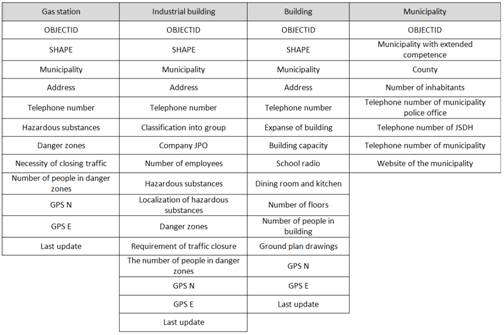
Figure 4 – The Geodatabase structure [source: Author]
The first column in Figure 4 is created to store information relating to petrol stations. The second column is dedicated to industrial buildings. The third column provides information about buildings usable for sheltering evacuees. The last column represents basic information about the municipality where the object is located. The geodatabase structure is filled by the data from previous chapters. Example of geodatabase layer is shown in Fig. 5.
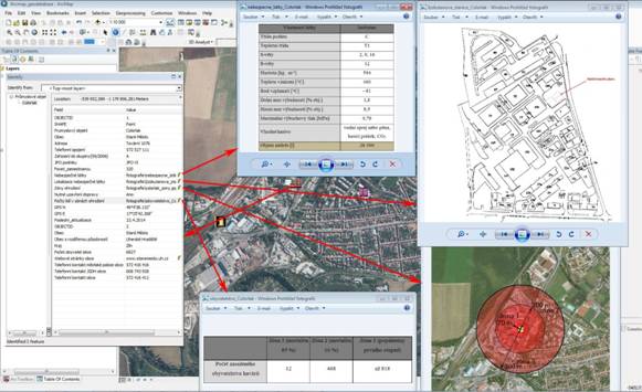
Figure 5 – The feature class layer for industrial object [source: Author]
Conclusion
The main idea and benefit of the article is to evaluate and optimize security situation in a municipality. This was achieved by modern information and communication technologies.
The article is focused on improving efficiency and simplification decision-making process relating to the solution of emergencies and crisis situations. It was natural to focus on modern technologies. The final output is in the form of the geodatabase which creates the integrated system that provides intuitive and necessary information about the selected objects.
My purpose was to create a new view of crisis management in Czech Republic. The system providing quality and accurate information about the objects associated with the solution emergency and crisis situations. For this purpose, it was necessary to interconnection and integration of relevant information obtained from emergency and crisis planning.
The geodatabase can be used as a system which marks the significant objects to the crisis and emergency management and planning. Another possible way to use the geodatabase is its integration into KOPIS data warehouse in a county.
Reference
[1] Místa koncentrace velkého počtu osob z hlediska jejich bezpečnosti aneb koncept
„crowded places“ a jeho praktické využití. In:Trendy, rizika a scénáře bezpečnostního
vývoje ve světě, Evropě a ČR – dopady na bezpečnostní politiku a bezpečnostní systém
ČR[online]. 2012 [cit. 2015-03-20]. Available from:
http://sbp.fsv.cuni.cz/SBP-254-version1-xwp_18.pdf
[2] BARTA, Jiří a Tomáš LUDÍK.TerEx – modelování a simulace[online]. Brno, 2012
[cit. 2015-03-24]. Available from: https://moodle.unob.cz/pluginfile.php/26278/mod_resource/content/1/Studijni_pomucka_TerEx.pdf.
Univerzita obrany.
[3] PROCHÁZKOVÁ, Dana.Bezpečnost a krizové řízení. Vyd. 1.
Praha: Police history, 2006, 255 s. ISBN 80-864-7735-5.
Aktuální číslo
Odborný vědecký časopis Trilobit | © 2009 - 2026 Fakulta aplikované informatiky UTB ve Zlíně | ISSN 1804-1795